

Geographer
Overview and Key Facts


Education

Median Pay

Job Growth

Jobs in 2034
What Do They Do?
A geographer could...


Overview Listen to this section
When you hear the word geography, you might think of maps and names of state capitals, but the work of geographers is much more than creating maps and identifying places. Geographers look at how people, places, and Earth are connected. They study the economy, social conditions, climate, and topography of a region to help answer questions in urban and regional planning, business, agriculture, and medicine.
Do You Have the Skills and Characteristics of a Geographer?

Core Tasks
Think about if you'd like the typical tasks a Geographer might do:Salary & Job Openings
Median Salary (Yearly Pay)
Future Jobs
Blast-Off:
(10% or higher)
(7% - 10%)
(5% - 7%)
(3% - 5%)
(0% - 3%)

Steps to Get There: Becoming a Geographer
High School Subjects to Study
Engineering
Career Pathway Listen to this section
To obtain a job as a geographer, students must have a college education.
Education- Typical Degree Needed After High School Listen to this section
high school credential
Typical degree for an entry-level position: Bachelor's degree ?
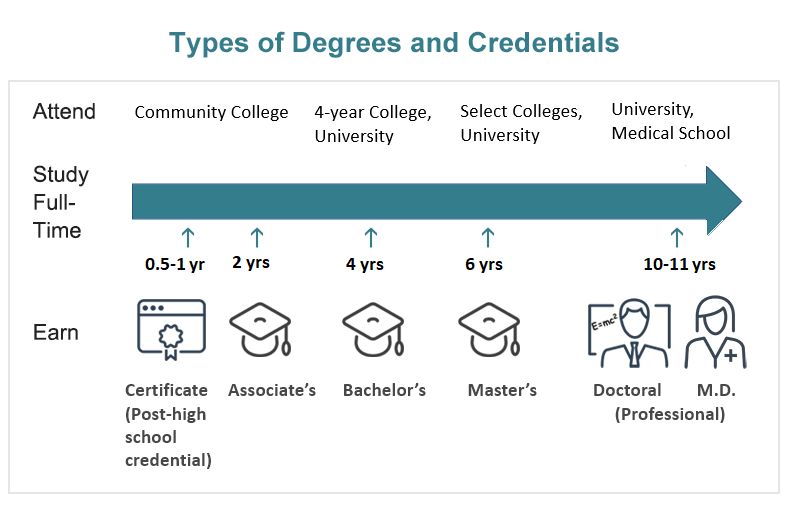
Federal jobs require a bachelor's degree, but graduate study or experience is an advantage. Requirements for high school geography teachers vary by state. Be sure to check the certification requirements by state. Candidates interested in teaching positions in two-year colleges and specialized and managerial posts in government and private industry must obtain a master's degree. Top positions in government and industry go to those who have a doctoral degree. A doctoral degree is also generally required for teaching positions in four-year colleges and universities.
Cartographers must have a bachelor's degree in geography with course work in drawing, design, and mathematics. Some colleges offer special courses in cartography, and nearly all cartographers expand their skills on the job. Specialists in Geographical Information Systems (GIS) need a college degree in geography or engineering and familiarity with computers. Many colleges offer courses in GIS systems and methods.
Companies That Hire Geographers
Try it Out with an Activity or Project
STEM Activities
STEM activities are fun hands-on explorations that usually take from 10 minutes to one hour and use readily available household or classroom materials while introducing you to STEM concepts common in this career.

Science Project Ideas
Project Ideas are in-depth STEM explorations that have a strong focus on controlling variables, taking accurate measurements, and analyzing data suitable for investigating the scientific method or the engineering design process.


On the Job
Role Models

Nature of the Work
Geographers are social scientists who study countries, regions, and cities through their economy, social conditions, climate, and topography. Geographers use their findings to solve problems in urban and regional planning, business, and agriculture. While many geographers are involved in environmental planning, most teach and do research in colleges and universities. Geographers also teach in high schools or work for federal and state agencies, private companies, or as self-employed consultants.
Geographers analyze distributions of physical and cultural phenomena on local, regional, continental, and global scales. Most geographers specialize in a particular aspect or method of geographic study. Economic geographers study the distribution of resources and economic activities. Political geographers are concerned with the relationship of geography to political phenomena, and cultural geographers study the geography of cultural phenomena. Physical geographers examine variations in climate, vegetation, soil, and landforms and their implications for human activity. Urban and transportation geographers study cities and metropolitan areas. Climatologists study weather patterns. Regional geographers or area specialists do research on a particular geographic region, ranging in size from a congressional district to entire continents. They use research methods from many aspects of geography to study all facets of an area, including its climate, economy, physical features, and culture. Medical geographers investigate health-care delivery systems, epidemiology (the study of the causes and control of epidemics), and the effect of the environment on health. Cartographers collect information and develop maps from aerial photographs, surveys, and other sources. They usually work for companies that publish maps and for the defense and intelligence departments of the government. Geographical information systems specialists use computer-aided technology to compile and analyze large amounts of data for environmental planning and natural resource management.
Most geographers use GIS technology to assist with their work. For example, they may use GIS to create computerized maps that can track information such as population growth, traffic patterns, environmental hazards, natural resources, and weather patterns, after which they use the information to advise governments on the development of houses, roads, or landfills.
In business, geographers help decide where to locate production facilities, find markets for goods and services, and do market analysis. Their advice is valued because they are trained to study physical features, such as natural resources, in tandem with cultural conditions, such as the availability of labor and transportation.
Work Environment
Geographers who teach work eight or ten months per year. However, college-level teachers may spend their summers working on research projects. Area specialists may travel to remote parts of the world. Graduate students often help professors with their research.
Geographers in government and business work in clean, comfortable offices. Those in top positions must often travel to attend meetings and to gather information for research.
More Information
Ask Questions
Do you have a specific question about a career as a Geographer that isn't answered on this page? Post your question on the Science Buddies Ask an Expert Forum.
Additional Resources
- American Congress on Surveying and Mapping: https://www.nsps.us.com/default.aspx
- American Geographical Society: https://www.amergeog.org/
- Association of American Geographers: www.aag.org
Sources
- U.S. Bureau of Labor Statistics BLS (2024). Occupational Outlook Handbook (OOH), 2024 Edition, Bureau of Labor Statistics. Retrieved August 25, 2025.
- National Center for O*NET Development O*Net Online (2024). National Center for O*Net Development. Retrieved August 25, 2025
- ConnectEd, YouTube. (2010, November 22). Day at Work: GIS Analyst ConnectEd. Retrieved April 9, 2014.
- Net Industries. (2009). Geographer Job Description, Career as a Geographer, Salary, Employment - Definition and Nature of the Work, Education and Training Requirements, Getting the Job. Retrieved September 14, 2009.
- esri. (2007, October). Spatial Patterns of Disease Inspire New Ideas on Possible Causes. Retrieved March 21, 2019.
- Kerski, Joseph. (n.d.). Joseph Kerski, Ph.D. – Geographer; Interview with "The Primary Geographer". Retrieved March 21, 2019.
- Rosenberg, M. (2017, June 5). What You Need to Know About Geography. Retrieved March 21, 2019.